Turnkey Services for Surface Mining
Many parts of the developing world lack a modern mining claims system, or are using an electronic registry that is underpinned with historical, out of date and often error-ridden cartographic products. This often results in mistaken or conflicting claim block delineation. Quite often, claimblock maps are devoid of any topographic, geographic, or significant cartographic data and therefore don't reference a claim location with respect to topography or significant physical features of interest (river valleys, outcrops, etc).
We often uncover errors in existing map products provided by the issuing mining agency or mining ministry of the host country. These are often gross errors, which, in the absence of accurate survey control, can leave a concession owner with an uncertain or mistaken belief of exactly which topo features are actually within their claimblock. While most senior producers have GIS teams to uncover these issues, these specialized resources are often not readily available to junior miners or mid-tier producers. As a result, serious complications can arise during exploration and development when it is discovered that - whether by error or ambiguity - the company is not legally entitled to surface features they believed were part of the claimblock.
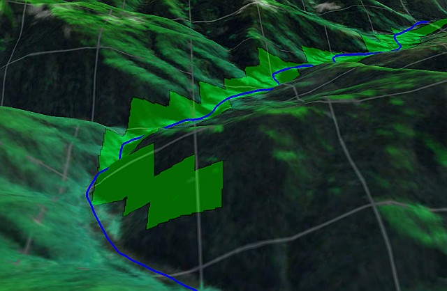
Above Left - Actual river position (blue) over alluvial claimblock (green). Reference Data is Landsat-7 ETM+ imagery & SRTM-3 DEM with an ASTER-GDEM-v2 hillshade overlay.
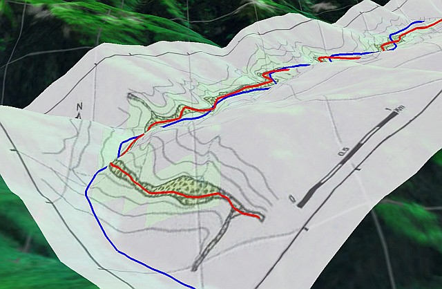
Above Right -Incorrectly documented river position (red) and cartographic overlay supplied by mining ministry.
A typical ISG siting and location report includes a complete description of the claimblock over the terrain, along with a categorized list of observations & discrepancies including error budgets, alignment residuals and an analysis across at minimum two sources of reference hillshade imagery & DEMs. It arms the client with factual information to allow claimblock adjustment or re-alignment prior to commencing site activities.
We also offer insight and recommendations for a variety of geospatial activities supporting the development of the property to client's expectations, along with detailed specifications for key elements, including:
ISG can also look beyond these requirements, working with your staff geophysicist in the delineation, specification, coordination and execution of many near-surface geophysical surveys, as well as hyperspectral surveys to identify specific sub-surface and surficial mineralogy. We also offer customized integrated database solutions for logging, visualizing, interpreting and analyzing all steams of geological, geophysical, geochemical, drillhole/borehole and bulk sample data, and can tie this into detailed geospatial data comprising of DEMs, orthophotos, detailed laser scans and HSI overlays.
We function as an extension to your existing team - no matter its size. In many cases we deal with areas that you may not have the ability to dedicate full-time resources to. Working with your team of stakeholders, we define a project scope that matches your specific objectives and budget, then execute these with an acute attention to detail providing an accurate, on-time value-added service.
Whether your need is a simple claimblock siting report, or a customized system to support multivariate testing & analysis, contact us for more information.